photo by Ishikawa Ken
While most other countries use the street based addressing system that an address is identified by “street number and street name”, the area based addressing system, which divides a large area into smaller blocks, is adopted in Japan. That means, a majority of streets in Japan have no names except for main streets, express ways and toll roads. In addition, Japanese addresses involves lots of numbers. This is another reason that makes Japanese addresses so confusing for people who are unfamiliar to them. If it is first time for you to travel to Japan, it is very unlikely to get straight to your destination just by using a map.
Japanese addressing system
Large area to small area
In the area based addressing system, areas are divided into smaller areas. “Prefecture” is the largest division, generally followed by progressively smaller divisions as in the following table. In writing, the largest division come first then continues to next smaller division. The postal address of the Tokyo Metropolitan Government Office, for example, is written as “東京都新宿区西新宿二丁目8番1号”, 東京都 (Tokyo-to: prefecture) →新宿区(Shinjuku-ku: special ward)→西新宿(Nishi-Shinjuku: area name)→二丁目(2 chome: city district)→8番1号 (8ban 1go: block number and building number).
|
Tokyo |
23 special wards (as independent as municipality in other prefectures) |
Followed by area name, “Cho-me (city district), “ban/banchi (block number)” and “go (building number) (e.g. 上野3丁目10番5号) |
|
|
City (Municipality) |
Followed by area name, “Cho-me (city district), “ban/banchi (block number)” and “go (building number) (e.g. 本郷三丁目24番1号など) |
||
|
Gun (District) |
Cho or Machi/Mura or Son (Town/Village) |
Followed by area name, “Cho-me (city district), “ban/banchi (block number)” |
|
|
Other “Prefectures” |
Designated City (Such cities have administrative wards. E.g. Tennoji-ju in Osaka) |
Followed by “Ku (administrative ward)”, area name, “Cho-me (city district), “ban/banchi (block number)” and “go (building number) (天王寺区中之島一丁目3番20号など) |
|
|
City(Other ordinary cities normally have no “wards”) |
Followed by area name, “Cho-me (city district), “ban/banchi (block number)” and “go (building number) (亀山町2番1号など) |
||
|
“Gun (District) |
Cho or Machi/Son or Mura (Town/Village) |
Followed by area name, “Cho-me (city district), “ban/banchi (block number)” |
|
About city district, block number and building number
If you are not familiar to the area based addressing, the most confusing things are these three: “Chome (city district)”, “Banchi or Ban (block number)” and “Go (building number)”. Chome (city district) may be rather easier to understand because it is just dividing one area (normally a suburb) into smaller blocks by using outstanding boarders such as large streets. In the address of the Metropolitan Government Office which was previously mentioned, “西新宿二丁目 (Nishi-Shinjuku 2 chome)” means the second of eight divisions of Nishi-Shinjuku area. By the way, some areas have no city districts (chome). In such areas, block number (banchi/ban) and building number (go) come right after area name.
The combination of block number and building number may be the most confusing part of Japanese addressing. Firstly, a block number indicates one of the divisions of an area (e.g. Nishi-Shinjuku 2chome), which is divided into 3000 to 5000m2 blocks. Such blocks are normally numbered starting from the closest corner to the center of the area such as a municipal office and continues in zig-zag way.
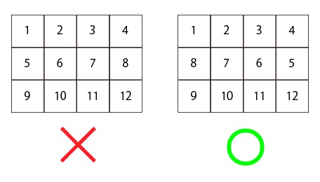
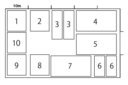
Secondly, the outline of the block is divided every 10 to 15m, then building numbers are allocated starting from the closest corner to the center of the area such as a municipal office and continues clockwise. As each section has 10 to 15m width, there may be two buildings that have the same number depending on the size of the building.
Useful tips to read Japanese address
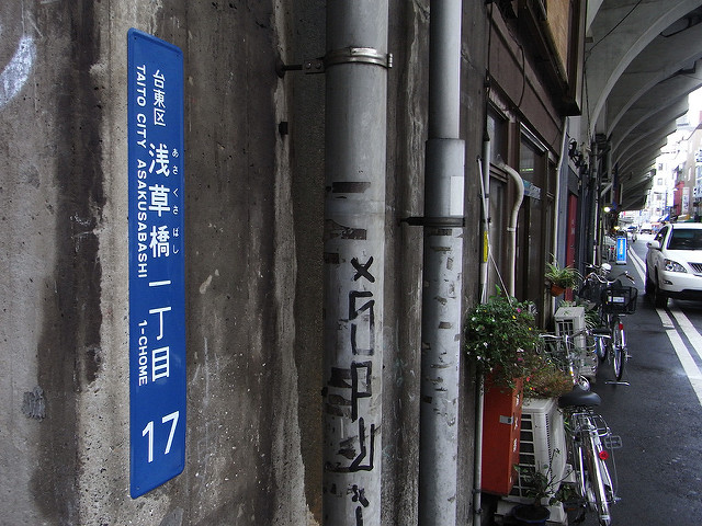
When you visiting a place by following address, the best way is to find a “town block indicator plate” and “residential number plate”. A town block indicator plate is a blue or green colored long rectangular metal plate with address down to block number, and can be found on telephone post or wall of a building. The address on a town block indicator plate is normally written in both Japanese and English. A residential number plate -/is a small metal plate in blue or green color that displays block number and building number (e.g. 8-1), which is about 15cm wide. It sometimes has area name beside the numbers, however, only in Japanese. You can find the destination address by following the rules that were previously explained.
No more lost in Japan
It is 21st century, but Japan still use the area based addressing. So far, the government has shown no intention to change the addressing system in Japan, so you have no other way than getting used to it. Otherwise, it is so inconvenient if you can’t read Japanese address. Of course you can let map app on your phone guide you on the street, blindly following a blue arrow on the screen. But this doesn’t sound very safe. So it is best that you know the addressing system in Japan. Then you can get to your destination with no efforts.
